Step aboard my blog for a pleasant voyage through the “Gospels from the Coast”. To begin with, it will help you to get oriented. Here is a map of the Lower Cape Fear Region.
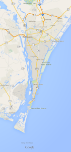
As you can see, the river flows in a more or less southerly direction from Wilmington to its mouth just below Southport. The Cape Fear River rises in the northern Piedmont of N.C. Its two major tributaries are the Deep River, which rises in High Point, and the Haw River, which rises north of Burlington. The confluence of these two rivers in Chatham County, just south of Chapel Hill, creates the Cape Fear. From there the river runs approximately 200 miles in a southeasterly direction to Wilmington. It is joined by several other significant rivers along the way and numerous small streams.
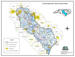
Here is a map of the Cape Fear River Basin.
In Wilmington, the Cape Fear River meets the Northeast Cape Fear River.
When she moved here, my wife remarked that the name of the Northeast Cape Fear demonstrated a notable lack of imagination. I concede the point. The Northeast Cape Fear is a fairly substantial river in its own right, draining most of New Hanover, Pender, and Duplin counties. It ought to have its own separate name. The Northeast Cape Fear is also significant because its tributaries drain two enormous natural preserves: Holly Shelter Game Land and Angola Bay Game Land. These amazing preserves are maintained by the N.C. Wildlife Resources Commission, primarily for hunting. They are unbelievably beautiful. Here is a picture of Holly Shelter in the fall and a picture of Shelter Creek, one of the main tributaries of the Northeast Cape Fear River. The second picture was taken at Holland’s Fish Camp on Highway 53 about three miles east of Burgaw.
[picture of Holly Shelter in fall]
[picture of Holland’s Fish Camp]
The Lower Cape Fear is actually a marine estuary—the water is brackish and the tidal influence is prominent. Such has always been the case, but dredging the shipping channel up to the N.C. State Port at Wilmington has increased the tides and the salinity of the water considerably. Occasionally at high tide the water will come up into the streets of downtown Wilmington. This happens in Charleston quite regularly, especially around Colonial Lake, and the problem is worse there since Charleston is low and flat. Wilmington, on the other hand, lies on a rather steep riverbank that rises forty or fifty feet from the river. Due to this incline, the river only comes up into the street that runs immediately alongside it, the aptly-named Water Street.
Here is a picture of the Wilmington waterfront. Notice the wooden Riverwalk promenade that extends along the riverfront. Pretty much everyone loves the Riverwalk. The second picture is the view from the Riverwalk looking south on a still evening. The bridge is the Cape Fear Memorial Bridge built in 1969. It is the highest bridge in North Carolina.
[picture of Wilmington waterfront]
[photo from Wilmington Riverwalk looking south]
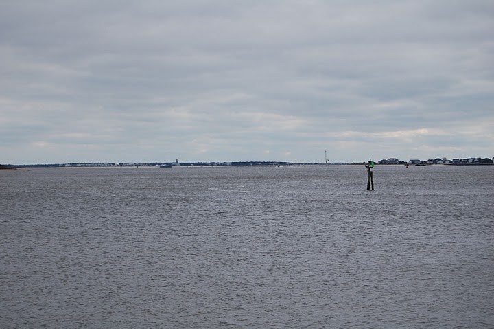
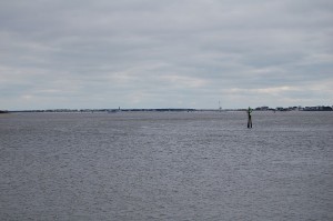
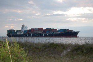
From Wilmington, the Cape Fear River marine estuary extends some twenty miles down to Southport. A mile or so beyond Southport the mouth of the river separates two barrier islands: Bald Head Island to the east and Oak Island to the west. Here is a photograph from Southport looking south to the mouth of the Cape Fear River.
You can only get to Bald Head Island by boat: there are no bridges. It is more-or-less a private island with vacation rentals, but you can take the pedestrian ferry for a day-trip. There are no cars on Bald Head, only electric golf carts. Bald Head Island is about four miles long from east to west. The mouth of the Cape Fear River is on the west of the island. Here is a picture from the Bald Head Island side of the mouth of the Cape Fear River.
The oldest lighthouse in North Carolina is on Bald Head Island. It’s named “Old Baldy”. Here is a picture of Old Baldy.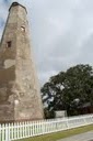
On the southeasternmost point is the actual Cape Fear. The shoals of Cape Fear are named Frying Pan shoals, and they extend forty or fifty miles out into the ocean. Even out that far, the shoals can be shallow enough for waves to break on them and ships to run aground on them. These shoals are so treacherous that early explorers gave the Cape its sinister name. Many times when the seas are rough, the swells will roll into each other from opposite sides of the Cape. If you’re sitting on the spit of sand watching the rough seas, it can be very dramatic. When the waves crash into each other they send spray way up into the sky—dozens if not hundreds of feet high.
My friend had his wedding reception out on the Cape when Tropical Storm Sandy was bearing down on the North Carolina coast in 2012. This was before she became a hurricane, then a superstorm, and wreaked havoc in the northeast. Fortunately for us, her effects were limited to torrential downpours, tropical-storm-force winds, and unbelievably rough seas on the shoals that provided a dramatic backdrop for the reception. Here is a picture of the shoals that night.
[photo of surf at Cameron’s wedding]